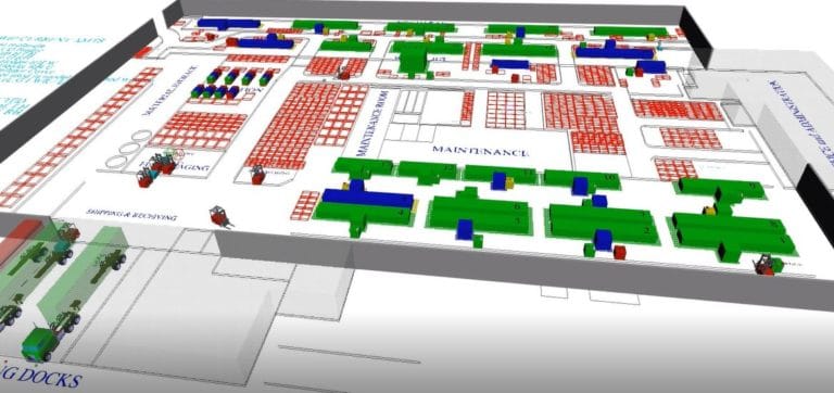
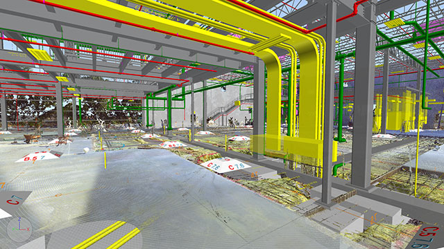
 What is Drone 3D Mapping? Drone 3D mapping refers specifically to imagery captured by drones through the use of laser scanning, aerial photogrammetry techniques and photogrammetry software which provides a realistic view of a site.
Field engineers receive the transmission from the drone in real-time and utilize the imagery and data from it in combination with emerging technology to help others visualize the location or site in their minds to a greater degree.
The Old Process
Digital design engineering requires drawings of the location for architects and engineers to work on. In the past, engineers relied on manual processes and measurements that they checked and annotated out in the field. They then brought this information back to the office where they could later create the 3D drawing for clients.
If they realized two measurements didn’t add up or that they forgot to add something, they would have to go back to the field to get it done. This made it almost impossible for companies to operate outside of their geographic area unless they were willing to take long flights and accept the cost of travel if they found any errors later on in their drawings.
The New Process
Thanks to the obvious faults of the old system, engineers have spent the past few years trying to find new ways to create a more accurate process. We wanted a solution that required less time and created fewer errors. Drone 3D mapping meets these requirements, even remotely, through the use of laser scanning. Field agents take the drones out into the field and use them to gather the information needed.
Back at the office, engineers receive the information in real-time. Our team can then evaluate this information as it comes in, spot any potential errors and ensure they have all the information they need. They can do all of this before the field agents leave the site, making a trip back to the physical location unnecessary. This helps to save on operating costs while helping us to maintain comparatively quick turnarounds.
The Benefits of Drone Surveying
 Naturally, drone mapping has some benefits over the more traditional method. However, we find that many clients don’t do mapping at all. If you have been getting by just fine without fully mapping out your farm or factory, you may wonder why you need to. What if we told you it could help save you money?
When purchasing property “as-built,” our drone mapping services can help with due diligence. The drones can either confirm or challenge the information in paperwork presented to you. This may get you out of a bad deal, give you pointers for negotiation or provide you with some peace of mind.
For sites that are already in use, drone mapping services help with improving safety. Some built-in hazards go unseen at ground level that you can better identify from a bird’s eye view. Creating a safer space for employees to work not only keeps workers on the job but also reduces the risk of personal injury litigation.
3 Key Benefits of Drone Mapping
As illustrated above, drones have many applications within the field of engineering and manufacturing. They also allow us to perform with greater efficiency, which our clients definitely appreciate. Of course, that’s not the end of the benefits offered by drone 3D mapping. Here are a few of the many reasons why we’re so excited about drone mapping services:
1. Improved Accuracy
When surveying a site, accuracy is an absolute must. When efforts are not accurate, you’re faced with the dim prospect of returning to the field and recreating work you’ve already performed. Not only does this cost precious time, but it can also delay projects and incur an even greater expense. That’s not something that a project manager will be happy to hear.
With drone mapping, proven aerial photogrammetry techniques and photogrammetry software can be combined with emerging technology. This makes for far greater accuracy than just using a traditional surveying approach alone. Drones allow for easier verification of data and more reliable results.
2. Increased Safety for Surveyors
Some sites entail many different risks. Avoiding these risks can be difficult for surveyors, especially when a site involves railway tracks, unstable terrain, or busy highways. Even then the proper safety measures are taken, workers may still be subject to unavoidable hazards.
Drones eliminate all hazards, without sacrificing the quality of the surveying results. Drones provide a bird’s eye view of the ground below, and without the need for a surveyor to put his or her safety at risk.
3. Better Looking Images & Graphics
While making sure surveyors are safe is crucial, the quality of the images taken is also important. This is especially true when communicating project plans to other parties, such as business associates or clients. Great visuals have the greatest impact, particularly on those who lack a comprehensive understanding of project plans.
Visuals are often crucial to getting others on board, whether applying for permits or seeking out financing.
Common Applications for Drone Mapping
As is always the case with new and emerging technology, people have questions. Among the most common ones we receive is whether or not drone 3D mapping or drone surveying is ideal for specific setups. So far, we have yet to encounter a situation where the answer is no. Here are some of the many sites where it would be a suitable option:
- Property development on raw or undeveloped land
- Treatment plants that are deep underground
- Inside factories and warehouses
- Home renovations
Drone Mapping Services
At Design Systems, Inc., we believe that drone 3D mapping is the way forward. One day, this technology will be as common in the field as tape measures. Contact us today via our contact form for a quote.
Industrial & Manufacturing Drone Mapping:
The aerial view is unmatched for both the aesthetics and the ability to provide an all-encompassing view. We had a similar idea in mind when we decided to employ drone mapping services such as drone 3D mapping to provide the visual data we needed to create 3D drawings for clients.
In addition to drone 3D mapping some of the other 3D scanning services DSI also specializes in Drone Surveying, Facility Design, 3D Factory Layouts, 3D BIM Models, 3D Drawings, Field Checking, Clash Detection, 3D scans for Reverse Engineering, 3D laser scanning services and more. Contact us today to find out more about how we can help.